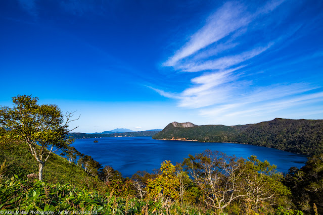
[Mt.Mashu in Hokkaido] Climbing Mt.Mashu overlooking the blue Lake Mashu with "Mashu Blue"
Lake Mashu, the second most transparent
lake in the world
Lake Mashu, located in the eastern part of
Hokkaido, is the second most transparent lake in the world after Lake Baikal in
Russia.
Lake Mashu is a caldera lake created by
volcanic activity. Due to the volcanic activity that started about 30,000 years
ago, it is thought that the volcano was originally shaped like Mt. Fuji and has
an altitude of about 2000 m. After that, a large eruption about 7,000 years ago
blew away the volcano and created a huge crater. Lake Mashu is where water is stored
in this crater. The cliffs extend to about 500m, and the water depth continues
to a depth of 100-200m.
According to a 1930 survey, it was the most
transparent lake in the world at 41.6m, which exceeds the transparency of Lake
Baikal in Russia at 40.5m. The current transparency is 19m, which is the second
in the world.
Lake Mashu was originally inhabited by fish
because there is no inflow or outflow of rivers. However, it is said that the
release of rainbow trout after 1926 is the cause of the deterioration of
transparency, but the exact reason is unknown.
Before the introduction of fish, Lake Mashu
had few living things, so it probably had a transparency that surpassed that of
Lake Baikal.
Currently, Lake Mashu is designated as a special
reserve in Akan National Park, and not only is all development prohibited, but
also human invasion is strictly restricted and protected.
I used to visit it several times in the
1980s, and even now, the scenery is so well protected that the scenery is
exactly the same as it was at that time.
Lake Mashu is called "Kintan Kamui To
(Lake of the Mountain God)" in Ainu language, and there is a legend of
Ainu on the small island "Kamuish Island" in the center. The Ainu
people, who do not have letters, have inherited the myth by oral tradition
(Yukara) from ancient times. For the Ainu people who think that God (Kamui)
dwells in all things, Lake Mashu must have been a sacred lake that should be
called the island of God.
Deep blue of Lake Mashu, "Mashu
Blue"
The unique color of Lake Mashu is called "Mashu Blue". It is said that it has a deep blue color due to the depth of 200m, the high transparency, and the hot spring components that exude from the volcano.
The summit of Mt. Mashu hits the outer ring of the explosion crater, and from the summit you can see the explosion crater of Mt. Mashu and the large caldera topography of Lake Mashu.
"Mt. Mashu" mountain climbing
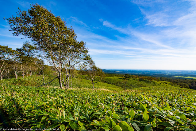
The general route for climbing Mt. Mashu is from the trailhead at the "Mashu First Observatory" on Lake Mashu. From the observatory, you can see Mt. Mashu towering on the opposite bank of Lake Mashu. From the trailhead to the foot of Mt. Mashu, you will first walk about 7km on the crater’s ridgeline.The gentle ups and downs have a wonderful view, and the large-scale scenery can be said to be unique to Hokkaido. The ridgeline has few trees and a pleasant meadow continues, so the road leading to Mt. Mashu is a panoramic view.
On the right side of the mountain trail,
beyond the slope, the Konsen Wilderness extends to the horizon. It is a vast
plateau in the eastern part of Hokkaido, and is a vast plain that extends to
Kushiro Marsh, Nemuro, and Nakashibetsu.
If you look back at the mountain climbing,
you can see Mt. Oakan, Mt. Meakan, and Mt. Akan Fuji. When you start to see Mt.
Mashu in the direction of the mountain trail, you will see Mt. Nishibetsu on
the right side of Mt. Mashu.
Trees such as Betula ermanii, birch, and
spruce grow on the ridgeline, and shrubs such as Leucothoe grayana and
Filipendula camtula grow near the summit. During the spring flower season,
Swertia japonica, lily of the valley, iwakinbai and iwagikyo are in full bloom.
Superb panoramic view from the summit
The summit of Mt. Mashu is a steep cliff with an explosion crater. The mountain trail aims at the summit from the slope covered with forest on the back side. It is a road that requires great care when climbing and descending as the slope increases as you approach the summit.When you finish the last climb on the steep slope and pass through the forest, you will see the dazzling blue of "Mashu Blue" under your eyes.
You can best understand how blue and
beautiful Lake Mashu is from the summit. There is nothing obstructing the
360-degree view, and you can see the vast scenery of Hokkaido.
In general, it's a good idea to think about
5 to 5 and a half hours, or 6 hours for a round trip.


Comments
Post a Comment